shrine to the prophet of americana

#geography (151 posts)

Geography lesson: Texas

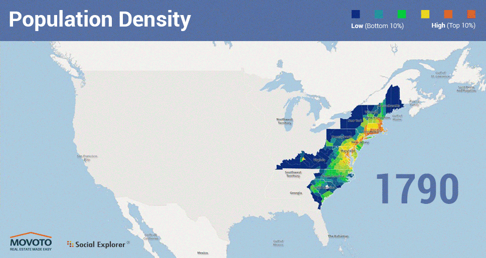
So the most important thing in understanding the development of Texas is that there are basically no rivers navigable further inland than Houston. That means it was mostly unsettled for so long not because it was unlivable or unfarmable but because there was no point to farming it, since you had no way of getting your crops to a demanding market.

This as much as the scrubland ecology is why the early economy was based on cattle, livestock being the only product that could move overland under its own power. Originally to Galveston for export to Caribbean slave plantations on land too valuable for cash crops to waste growing protein, later to the furthest south railhead for shipment to the stockyards of Chicago (which, built to connect the Great Lakes to the Mississippi River system, was and still is the linchpin of the American transportation network)

And this still matters! Like, one theory of modern American politics comes down to Texas and other “Sun Belt” cities offering better “affordable family formation”, in turn because they can sprawl outward 360° over the empty plains, as compared to other cities constrained by geography.

But that’s because those cities only grew in the Industrial Age past when cities had to be located around a water feature (or OK, maybe a mountain pass) in order to matter. Dallas grew up where it did because it was at the intersection of two railroads. Compare to the original Texas power city of Galveston, which (until a devastating hurricane) was not only on the coast but a Manhattan-style island

Tagged: geography amhist texas

A calm morning in Namego Valley takeshi.wa

maureen2musings:

A calm morning in Namego Valley

takeshi.wa

Tagged: geography

U.S Population changes.

mapsontheweb:

U.S Population changes.

Tagged: amhist geography

Fastest paths through road networks in New York State to New York City.

mapsontheweb:

Fastest paths through road networks in New York State to New York City.

2 striking things:

1) how I-86 (the thick lower east—>west artery) is clearly aligned to keep it within the state (rather than ever crossing into northern PA) as a residue of its history as State Route 17

2) how the Erie Canal, once the most important inland transportation route in America, is NOT replicated by road traffic, instead two separate parts of its east—>west central tier alignment are branched off of south—>north arteries to serve the communities it catalyzed

Geography!

Tagged: geography

@wirehead-wannabe said What’s the deal with L.A. then? LA has no natural harbor, it started out as an inland nowheresville,...

kontextmaschine:

@wirehead-wannabe said What’s the deal with L.A. then?

LA has no natural harbor, it started out as an inland nowheresville, founded as a feudal agricultural settlement by the seasonal Los Angeles River feeding the San Fernando Mission at the northern mouth of the valley. San Diego was the major city of the region.

Eventually it came time to build a southern transcontinental (“Southern Pacific”) railroad route, with San Diego as the obvious western terminus but San Francisco had issues.

San Francisco, swollen by the Gold Rush, terminus of the first transcontinental route, was the dominant power in California and didn’t want a rival, pulled enough strings to redirect to LA.

LA built an artificial breakwater and a port down by San Pedro several miles south of the city, before that they used absurdly long-ass piers off the western coast around Malibu and Santa Monica.

Then narratively unrelated to any of this there was oil discovered in the hills, which generated capital and drew Eastern money, Pasadena became the west coast WASP capital, or at least Palm Beach-equivalent. LA became self-sustaining.

Then the movie industry moved there for the weather and distance from Thomas Edison’s IP-enforcing goons

Then during WWI the aircraft industry got big because there was infrastructure and a population of workers in coastal shipping range of the NorCal/Oregon lumber industry, but WITHOUT SF/Seattle-style labor radical tendencies

Then during WWII that got even bigger and the US realized it needed to build up its Pacific (Japan- and Russia-facing) coast, which was honestly still frontier at that point

And the rest is history

Tagged: rerun geography really the west coast palm beach is palm springs

yeah, great place to build stuff guys, nothing could possibly go wrong

rabbiteclair:

yeah, great place to build stuff guys, nothing could possibly go wrong

Tagged: geography army corps of engineers

Avulsion This beautiful gif was prepared using data from the long-lived Landsat series of earth orbiting satellites, You are...

earthstory:

Avulsion

This beautiful gif was prepared using data from the long-lived Landsat series of earth orbiting satellites, You are looking at the course of the Padma River in Bangladesh and how its course has varied over the last 30 years. This is a textbook example of river erosion processes. When rivers begin to meander, they evolve by growing their meanders wider, until the meander finally gets too sinuous and the river finds another path. Pick a point where the river bends and watch what happens – the outer bank of the river erodes and sediment deposits on the inner side of the curve, making the river arc farther outwards. The outer side of the river that is eroding is called a cut bank, and sediment is deposited on the inside of the river building a point bar.

Keep reading

Tagged: geography

US Population per sq. mile.

mapsontheweb:

US Population per sq. mile.

Tagged: geography ’merica

Here's How America Uses Its Land

Here's How America Uses Its Land

jakke:

On one hand all of this is absolutely fascinating and on the other hand the United States is mostly a factory for cows and cow fuel. 

Tagged: not wrong geography merica

in the 1990s it was an issue that we pretty much agreed that cigarette smoking induced terminal disease and also instead of...

in the 1990s it was an issue that we pretty much agreed that cigarette smoking induced terminal disease and also instead of universal healthcare America routed its welfare state through employers but also this “Medicaid” charity-case program which was kind of coopted from state programs which were kind of expanded from a tradition of county programs which were kind of inherited from the parishes of the Catholic Church back in the English Reformation

but the result of all this was now that we had better healthcare for this shit than pointing and saying “you’re gonna die” governments at every level felt politically obligated to provide and thus pay out the nose for it and were ticked

except the areas of the country that grew tobacco were in a specific slice of the southeast that was right in the process of switching party alignment in a narrowly balanced Congress so no one could afford to press them at the federal level

that was the last time I can remember where an important national issue was decided/had political impact on lines of geography rather than ideology

(the issue was settled extracongressionally through a legal settlement in something like a multi-state class action that at least violated the spirit of the Interstate Compact Clause)

Tagged: amhist geography

This person is my new best friend Farming systems need to fit into their natural and social environment. Sometimes we describe...

kawuli:

This person is my new best friend

Farming systems need to fit into their natural and social environment. Sometimes we describe this as a socio-ecological niche.

Tagged: geography

Acres of Prime Farmland, USA, 1997.

mapsontheweb:

Acres of Prime Farmland, USA, 1997.

Tagged: geography

oh one thing interesting about Japanese history that you can find English sources on was that it had like no good transit...

oh one thing interesting about Japanese history that you can find English sources on was that it had like no good transit routes, it was so steep you had the southern coastal waters where currents/winds would sweep you out into the middle of the Pacific

and the northern waters which were practically arctic tho they at least connected to China & Korea enough for some fun piracy

and Lake Biwa in the middle which was like the Great Lakes for being an industrial center but maybe more like the African Great Lakes for not having a useful outlet

past that it was like footpaths ‘cause until Hokkaido (which was the Canada [or Ireland] to Japan’s England SURPRISINGLY RECENTLY) it’s not like anyone had plains to fodder traction animals outside Kanto anyway

Tagged: geography

Shrub: Shrublands of America.

mapsontheweb:

Shrub: Shrublands of America.

Tagged: geography

it’s funny how there’s this huge, gratuitous jag down to get a Red Sea port and that’s like Israel’s least controversial border

it’s funny how there’s this huge, gratuitous jag down to get a Red Sea port and that’s like Israel’s least controversial border

Tagged: geography

Drainage basins of European rivers.

mapsontheweb:

Drainage basins of European rivers.

this as vs. all the little east-of-the-Appalachians watersheds and then contrasted with the humongo Mississippi watershed explains so much of how America happened

Tagged: geography

half the time mapsontheweb reads like a backwards reasoning game like "what obscure nationalist forum dispute did someone try to...

half the time mapsontheweb reads like a backwards reasoning game like “what obscure nationalist forum dispute did someone try to win with this map?”

Tagged: nationalism mapsontheweb geography

Rivers of Germany.

mapsontheweb:

Rivers of Germany.

Tagged: geography

How many times each European country is wealthier (GDP per capita PPP) than the continent’s poorest country (Moldova).

mapsontheweb:

How many times each European country is wealthier (GDP per capita PPP) than the continent’s poorest country (Moldova).

Tagged: geography

@wirehead-wannabe said What’s the deal with L.A. then? LA has no natural harbor, it started out as an inland nowheresville,...

@wirehead-wannabe said What’s the deal with L.A. then?

LA has no natural harbor, it started out as an inland nowheresville, founded as a feudal agricultural settlement by the seasonal Los Angeles River feeding the San Fernando Mission at the northern mouth of the valley. San Diego was the major city of the region.

Eventually it came time to build a southern transcontinental (“Southern Pacific”) railroad route, with San Diego as the obvious western terminus but San Francisco had issues.

San Francisco, swollen by the Gold Rush, terminus of the first transcontinental route, was the dominant power in California and didn’t want a rival, pulled enough strings to redirect to LA.

LA built an artificial breakwater and a port down by San Pedro several miles south of the city, before that they used absurdly long-ass piers off the western coast around Malibu and Santa Monica.

Then narratively unrelated to any of this there was oil discovered in the hills, which generated capital and drew Eastern money, Pasadena became the west coast WASP capital, or at least Palm Beach-equivalent. LA became self-sustaining.

Then the movie industry moved there for the weather and distance from Thomas Edison’s IP-enforcing goons

Then during WWI the aircraft industry got big because there was infrastructure and a population of workers in coastal shipping range of the NorCal/Oregon lumber industry, but WITHOUT SF/Seattle-style labor radical tendencies

Then during WWII that got even bigger and the US realized it needed to build up its Pacific (Japan- and Russia-facing) coast, which was honestly still frontier at that point

And the rest is history

Tagged: amhist geography los angeles history