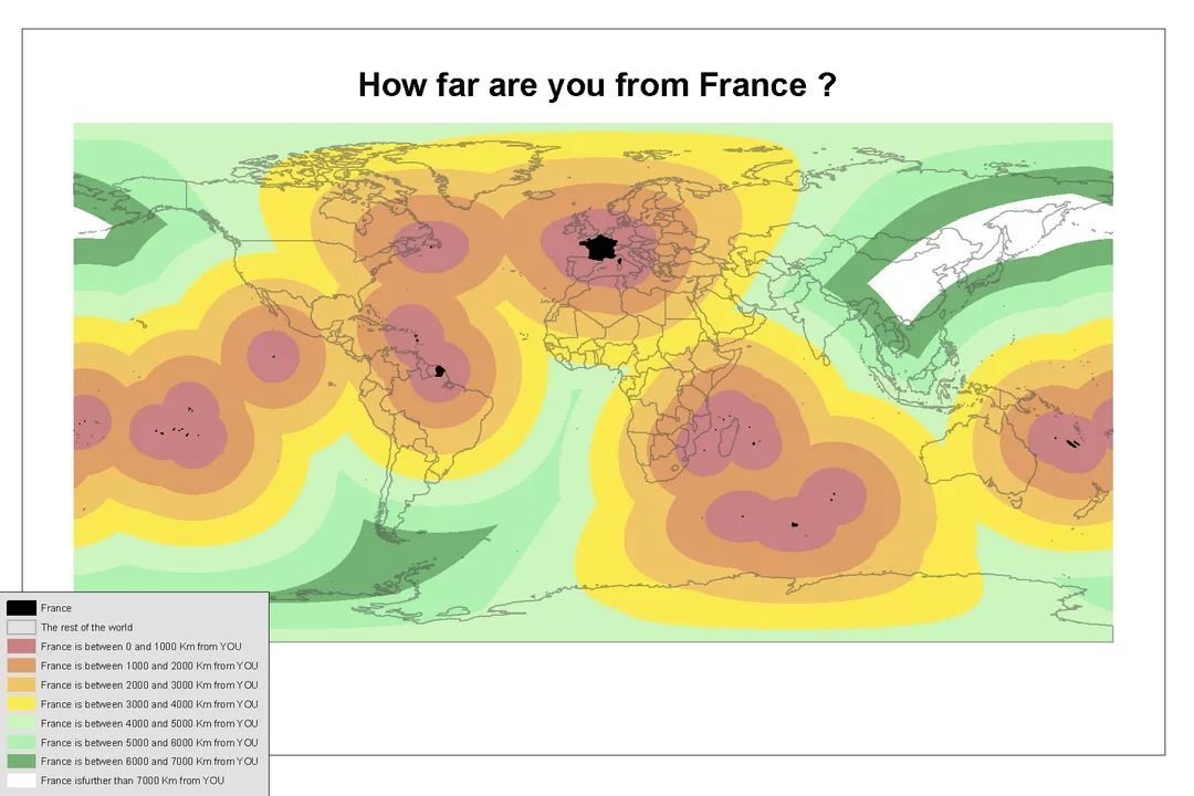
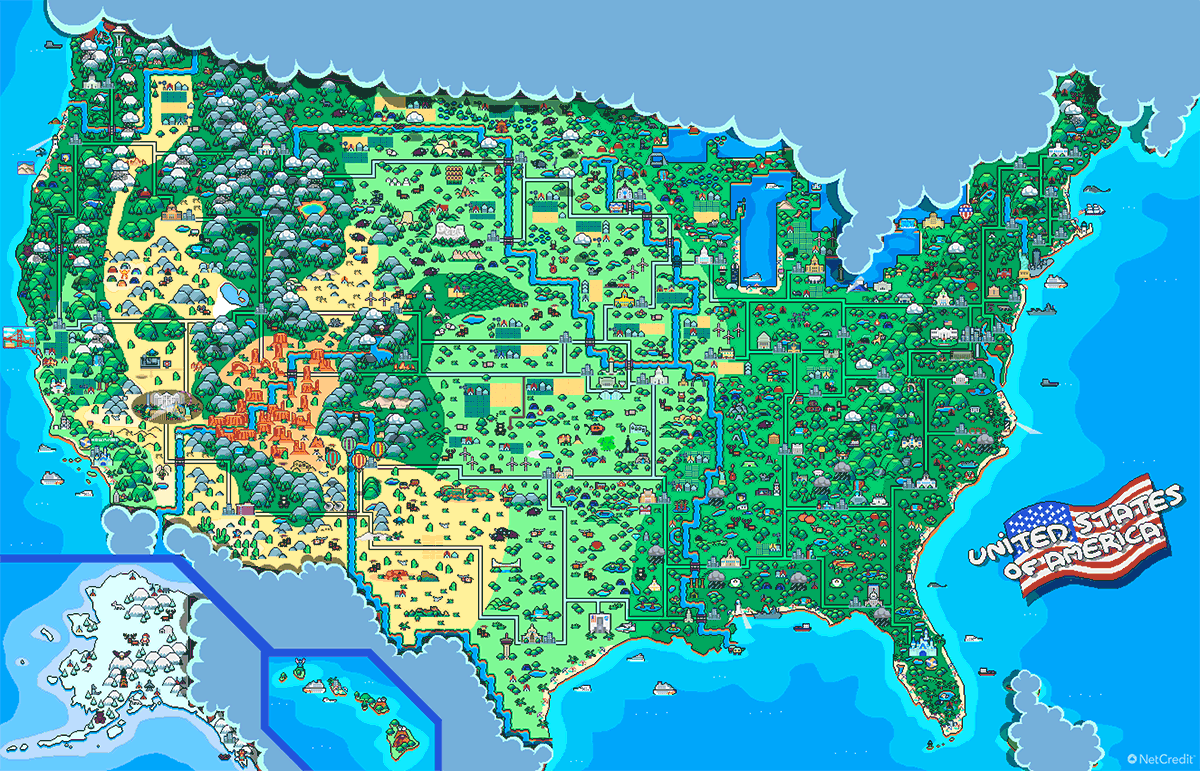
June Gloom, the Santa Ana winds, the way San Francisco summers are the cool season, air passing back and forth past two mountain ranges on the Columbia River Gorge…
Basically everywhere I’ve been on the West Coast has had some kind of weird local convection-based weather pattern, which I guess is what happens when your coast is an ocean running directly into a mountain range
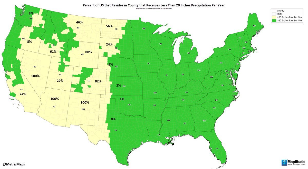
An important thing to understand about the United States is the ocean currents on its coasts circle clockwise, so on the East Coast warm water comes up from the Caribbean and the coast is warmer than you would expect from that latitude but on the West Coast cold water comes down from Alaska so the coast is cooler than regular
The main factor in Portland weather is the gorge cutting through two mountain ranges, creating an airflow corridor between the ocean and the hot inland plains
So after the sun goes down it stays hot and a little more stifling even until 2AM or so as the hot inland air passes by on the way out to sea
The flip side is the morning and afternoon aren’t as hot as they might be otherwise, because they’re moderated by the cool sea air coming in. Which is to say if it’s this hot already at 9:45, woo boy is it gonna get bad
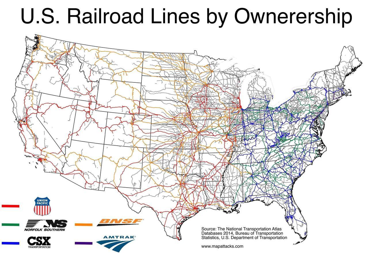
O'Hare is America’s keystone airport largely because America developed with Chicago at the hub of our rail networks, in turn because it was already the interconnection between our two major internal waterways, the Great Lakes (linked to NYC and the Atlantic by the Erie Canal) and the Mississippi system (including its tributaries)
Legitimately concerned I might not have seen enough regular canyons to get the context to properly appreciate the Grand Canyon
Like, I’ve seen the Columbia River Gorge, but not on to the Snake River Canyon, and honestly my biggest exposure to that kind of river-eroded landscape is from Pennsylvania and upstate New York, with more rainfall - so more direct erosion, more vegetation both holding soil together and turning rock into soil, broader valleys, freezing-thawing-cracking rendering canyon walls imperceptible behind scree slopes, etc.
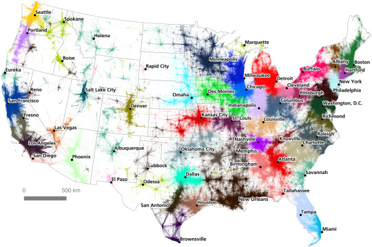
“Hidden spaces,” bioregional cultural identity, and suburban decay in the hinterland of America: On how ecology and environmental geography influence local resource extraction industries, which in turn creates boundaries between cultural regions and determines locations of wealth disparity.
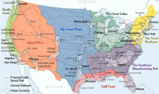
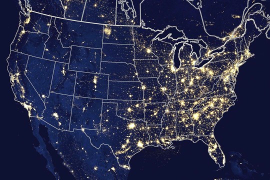
Map 1: The areas of urban influence over adjacent rural land, produced by Garret Dash Nelson in an influential 2016 study of urban influence over economic geography of nearby regions. Map 2: By Claire Trainor of University of Wisconsin-Madison, combining the 7 major cultural region boundaries of Joel Kotkin with the urban megaragions recognized by Regional Plan Association. Map 3: Human-created nighttime lighting (source).
All the stories I tell about the border region between Southern
Oregon and Northern California, to take one example, simply wouldn’t
exist if it hadn’t been for the way that capitalist accumulation drove
the need for violent settlement, reshaped the area’s basic hydrology and
ecology, and then instigated a whole series of crises that wrecked the
mining, timber, and farm industries. So the picture is then one where
there exists this lower class, working in the black markets, the grey
markets, or on contracts fighting wildfires, for example, because this
is really the only way to buy food and pay rent and pay taxes. It’s not
some sort of lifestyle choice. What seem to be cultural peculiarities
are actually rooted in this class experience. And at the same time you
have the formation of this other class of landowners and industrialists
who put forward a claim to “white working class” identity, but really
they’re just using cultural signifiers to obscure the fact that they own
the vast remainder of the land that the government doesn’t already own,
and the few mills and mines and factories that still run, and honestly
many of them are just living off income from farm subsidies and, like,
an Arby’s franchise near the freeway. But because the Bundys wear
Carhartt jackets you get all these urban commentators talking about the
revolt of the “white working class.” Regardless of how it gets
distorted, though, you can see how a certain class character is
basically shaped by these conditions of production.
What I call the “hinterland” is central to this simply because of how
production has been changing. I said above that the book is a work of
communist geography. The notion that class emerges from the character of
production—and that class is inherently conflictual—is pretty clearly
packaged in the “communist” part, but it’s also important to remember
the “geography” portion, because the economy takes shape in space. That
means that class takes on a spatial pattern as well, and the conflicts
that arise from it become embedded in real territories. I don’t mean
this figuratively, either, because for about a decade now it’s been very
fashionable for academics to use these geographic metaphors, explaining
how concepts “map onto” one another, or how ideas are
“territorialized.” What I mean is that there are factories and
warehouses and ports and rail yards out there somewhere, they take up
space, they tend to cluster and sprawl in certain patterns and certain
locations, and the people who work in them also live somewhere. So
really the focus on the hinterland is an attempt to puncture this
amorphous view of geography that we’ve sort of intuitively absorbed,
helmed by the notion that the downtown core of the “Global City” is
somehow the real heart of the economy, since it’s where the “knowledge”
is—whether because of its concentration of tech workers, producer
services, or the so-called “creative class.” I’m saying, no, in fact,
the heart of the economy is still the production, processing, and
transit of goods, and this largely does not take place downtown.
The hinterland is basically the space that lies beyond the
administrative centers of the global economy, which tend to be centered
in the downtown cores of (largely coastal) metropoles. Obviously, there
is enormous variation in what this space looks like. But I use the word
“hinterland” to try to capture the idea that these places are not
peripheral in the sense of being on the “edge” of capitalism and
therefore having relative autonomy, where self-sufficiency and
subsistence might be possible. They are fully dependent, subordinate to
these administrative centers. But their priority does differ: the “far”
hinterland is lowest in this hierarchy, suitable for the sort of things
that are best kept out of sight. At its best, it is defined by some sort
of extractive primary industry (mining, farming, timber, etc.); at its
worst, it’s just a sort of abandoned zone, dominated by informal work
and black markets, where small towns desperately compete with one
another to be the host site for a new prison or landfill. And it’s
important to note that these spaces don’t necessarily map directly onto
our intuitive idea of urban and rural. The far hinterland is certainly
mostly a rural space, but it would include that deep rust belt decay you
see in Flint, MI, for example. One part of the concept’s utility, then,
is to point out that the experience of poverty in rural Kentucky is
actually not going to be that fundamentally different from the
experience of poverty in “inner city” Detroit—the two will be distinct,
but both will certainly be far more similar to one another than to the
average life experience of someone born to a moderately wealthy family
in Boston or Seattle. At the same time, you also have these islands of
affluence in rural areas, which are usually either leisure centers (like
Aspen, CO), or simply commuter exurbs, and these places have a much
closer relationship with the urban core despite their distance.
–
Phil A. Neel, in an interview with The Brooklyn Rail, discussing his recently published Hinterland: America’s New Landscape of Class and Conflict (2018 - University of Chicago Press).
This book is full of holistic analysis about the intersections of ecology, culture, and wealth disparity. This is a good book about how natural ecology/landscape produces distinct cultural regions, and a good book about the recent history and growth of major urban areas. I recommend it for anyone interested in bioregionalism, ecology in the US, cultural regions, regional Gothic, suburbia and urban planning, the Rust Belt, political geography generally, etc.